
Page 13 - 2024 - 51.1
P. 13
habited by people indigenous to the area (who were at least curious and
at best defensive about this strange party of men and animals trekking
north.)
Major, who was a revered U.S. Navy Astronomer from Wash-
ington, D.C., relied on box and pocket chronometers, as well as several
other instruments, that he transported four hundred miles from San
Francisco in a “light spring wagon” (Pace 2018, p. 5), for his astronomical
calculations of longitude. Major and his crew took thousands of measure-
ments starting on July 13, 1868 to determine their location once at Camp
Bidwell, but an earthquake on August 27 interrupted the functioning of
their timepieces. Paul Pace writes that “there was always some doubt
about the accuracy of the almanacs and ephemerides then in use;” this
factor, along with the rough ride that the instruments had received on
their journey and the malfunctioning of the chronometers during the
earthquake, surely impacted the accuracy of Major’s longitude observa-
tions for his determination of the intersection of the 42 parallel of lati-
nd
th
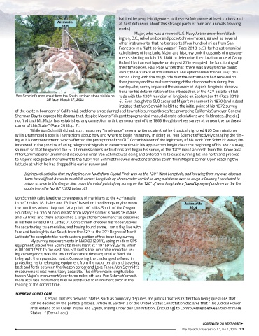
Von Schmidt’s monument from the South; scribed stone visible on tude with the 120 meridian of longitude on September 11 (Pace 2018,
SE face, March 27, 2022 6). Even though the GLO accepted Major’s monument in 1870 (and indeed
insisted that Von Schmidt hold it as the initial point of his 1872 survey
of the eastern boundary of California), problems arose during local township surveys thereafter, prompting California Surveyor-General
Sherman Day to express his dismay that, despite Major’s “’elegant topographical map, elaborate calculations and field notes…[he did]
not find that Mr. Major has established any connection with the monument of the 1863 Houghton-Ives survey at or near the northeast
corner of this State’” (Pace 2018, p. 7).
While Von Schmidt did not start his survey “in advance,” several writers claim that he drastically ignored GLO Commissioner
Willis Drummond’s special instructions about how and where to begin his survey. In doing so, Von Schmidt effectively changing the tim-
ing of his commencement, which affected the perception of the GLO Commissioner of the legitimacy of his work. Von Schmidt was quite
interested in the promise of using telegraphic signals to determine time in his approach to longitude at the beginning of his 1872 survey,
so much so that he ignored the GLO Commissioner’s instructions and began his survey of the 120 meridian north from the Tahoe area.
th
After Commissioner Drummond discovered what Von Schmidt was doing and ordered him to cease running his line north and proceed
to Major’s recognized monument to the 120 , Von Schmidt followed directions and ran south from Major’s corner. Upon reaching the
th
latitude at which he had dropped his earlier survey and
[b]eing well satisfied that my flag line, run North from Crystal Peak was on the 120° West Longitude, and knowing from my own observa-
tions how difficult it was to establish correct Longitude by chronometer carried so long a distance over so rough a Country, I concluded to
return at once to the Oregon line, move the initial point of my survey on the 120° of west longitude a found by myself and re-run the line
again from the North” (1872 Letter, 6).
Von Schmidt calculated the convergency of meridians at the 42 parallel
nd
to be “3 miles 18 chains and 73 links” based on the discrepancy between
the two lines where they met “at a point 100 miles South of the Oregon
Boundary.” He “ran a line due East from Major’s Corner 3 miles 18 chains
and 73 links, and there established a large stone monument” as described
in his field notes (1872 Letter, 7). Von Schmidt checked his “observations
for ascertaining true meridian, and having found same, I ran a flag line with
fore and back sights due South from the 42 to the 39 Degree of North
nd
th
Latitude” to complete the northeastern portion of the boundary survey.
My survey measurements in NAD 83 (2011), using modern GPS
equipment, placed Von Schmidt’s monument at 119°59’58.25”W, which
is 00°00’17.50” to the east. Von Schmidt’s line, which he corrected us-
ing convergence, was the result of accurate time acquired at Verdi via
telegraph, then projected north. Considering the challenges he faced in
protecting his timekeeping equipment from the rocky terrain and traveling
back and forth between the Oregon border and Lake Tahoe, Von Schmidt’s
measurement was remarkably accurate. The difference in longitude be-
tween Major’s monument (over three miles off) and Von Schmidt’s much
more accurate monument may be attributed to instrument error in the
reading of the correct time.
SUPREME COURT CASE
Certain matters between States, such as boundary disputes, are judicial matters rather than being questions that
can be decided by the political process. Article III, Section 2 of the United States Constitution declares that “The Judicial Power
shall extend to all Cases, in Law and Equity, arising under this Constitution…[including] to Controversies between two or more
States….” (Cornell.edu)
CONTINUED ON NEXT PAGE u
The Nevada Traverse Vol.51, No.1, 2024 11