
Page 15 - 2024 - 51.1
P. 15
While the Court’s decree was definitive and final and the Special Master’s investigation thorough, it has been instructive for a land sur-
veying student to explore the processes that led to each of the monumentations of the northeastern corner of California. Variations in
record-keeping and timekeeping, political influences, technological advances, personal skill sets, and the fever to expand into indigenous
territories all factored into the discrepancies among the three corners.
CONCLUSION
The existence of new States and Territories of the still-growing United States depended on the monumentation of corners;
defining geographical boundaries could be no more fundamental in the establishment of these new political spaces. In this investigation,
I sought to understand how it came to be that three survey crews placed a highly significant corner of three States in vastly different
locations, culminating a century later in a U.S. Supreme Court decision. Given all of the variables that I have identified, it appears that
the basic reason for these discrepancies involves time. The Kidder party representing California and the Nevada Territory ran out of time
and hurriedly threw up a rock mound in 1863. Daniel Major was passionate about his instruments but could not protect his timepieces
from the perils of traveling over a rough landscape and the forces of nature. Allexey Von Schmidt faced the same travails of terrain in
his forays to the high desert landscape of northeastern California, southern Oregon, and northwestern Nevada. Von Schmidt ignored his
special instructions and ended up adding time to his survey.
From a project management perspective, time was also a deciding factor in my own efforts to survey these corners. In a recent
edition of the Nevada Traverse, Trent Keenan and Kristina Poulter presented several phases of project management, as described by Tony
Mintrup:
• Step 1: Project initiation – Defining the scope of the project, including a timeline, objectives, stakeholders, and risks.
• Step 2: Project planning – Developing milestones for the project, including equipment needs, access, and obtaining neces-
sary resources to operate.
• Step 3: Project execution – Breaking tasks up into doable parts to adhere to the schedule.
• Step 4: Project completion – Reflecting on successes and lessons for moving forward (Keenan and Poulter 2022, 22-25
and 44).
It is useful to apply these four
steps to this capstone project in order
to gauge the project management
implications of such an endeavor. In the
Project Initiation and planning phases, I
developed a rough timeline and scope of
the tasks involved in locating the three
monuments, but I should have deter-
mined the private land status of Major’s
monument sooner so that I could have
reached out to the landowner in enough
time to gain permission to access his
unusual property. The relatively close
relationship among the locations as well
as the proximity to my own community
in Surprise Valley would have made it
practicable to accomplish the survey in
one very long day or two 8-hour days in
the field, had I made arrangements in a
timelier manner. Each trip was approxi-
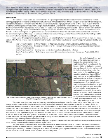
Map showing three monuments marking the northeast corner of California, as surveyed by author March mately 80 miles roundtrip, much of that
– May 2022 (Google Earth image 5/17/2022)
at 35 miles per hour or slower.
The project execution phase went well over the three half-days that I spent in the field searching for two of the three monu-
ments, with the exception that I neglected to bring Von Schmidt’s field notes with me on the day I located his monument. Doing so
would have allowed me to search for the bearing trees that he called for in his survey. I believe finding those trees or their remnants is
an important part of a retracement, so I will return to the field again to locate those features, which will add another day in the field; if I
can time this visit with my trek to the Major monument, it will be well worth the miles and time. Surveyors are tasked with following in
the footsteps of the original surveyors – not near their footsteps – so it is crucial to utilize the artifacts of our predecessors to under-
stand and retrace their work. Having Minto’s notes with me, for instance, allowed me to find the scribed bearing tree as he described
it in his field notes. The data processing stage of the execution phase was relatively short, although more consideration and time went
into developing a meaningful way to share the findings.
Once the execution phase was complete, the project completion step naturally resolved itself, with a completed document and
visual displays that will lend hopefully themselves to publication.
The great lesson of the conundrum of the monumentation of the northeastern corner of California mirrors the field and man-
agement aspects of the land surveying profession – if we develop an awareness of time as both a qualitative and quantitative factor in
everything from planning a timeline for a project to accurately and efficiently locating boundaries on the earth, land surveyors will truly
be able to tell the story of the land for the benefit of all concerned parties.
CONTINUED ON NEXT PAGE u
The Nevada Traverse Vol.51, No.1, 2024 13