
Page 10 - 2024 - 51.1
P. 10
The Conundrum... continued from previous page
I found Major’s corner
monument 2,158’ west of Minto’s
monument, on the slope of a rocky
hill north of Twelve Mile Creek.
Major’s notes on his monumenta-
tion situate the initial point and
monument at the intersection of the
120 Meridian and 42 Parallel, on
th
nd
Southern Boundary of Oregon, situ-
ated on North side of a long rocky
hill 13 chs.[858’] North of a stream
known as ‘12 mile Creek’…also 10
cha. [660’] north of a new Military
road from Camp Bidwell and Sur-
prise Valley to Fort Warner (Major
1868, 3).
Major described the work he and
his crew did to set his corner
monument:
Made deep excavations near rocky
ledge. Deposited three large black
bottles (glass), also charred cot-
tonwood stakes 30 inches long and
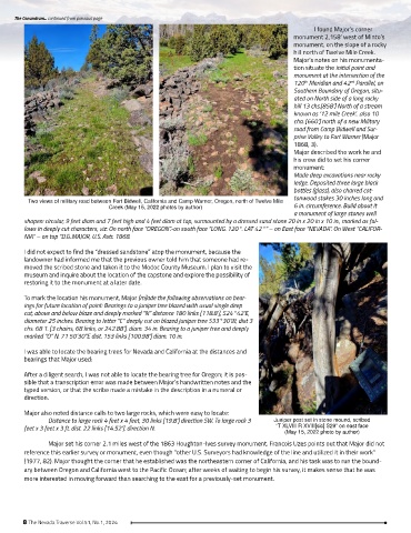
Two views of military road between Fort Bidwell, California and Camp Warner, Oregon, north of Twelve Mile
Creek (May 15, 2022 photos by author) 6 in. circumference. Build about it
a monument of large stones well
shapen: circular, 9 feet diam and 7 feet high and 4 feet diam at top, surmounted by a dressed sand stone 20 in x 20 in x 10 in., marked as fol-
lows in deeply cut characters, viz: On north face “OREGON”.-on south face “LONG. 120°. LAT 42°” – on East face “NEVADA”. On West “CALIFOR-
NIA” – on top “D.G..MAJOR, U.S. Astr. 1868.
I did not expect to find the “dressed sandstone” atop the monument, because the
landowner had informed me that the previous owner told him that someone had re-
moved the scribed stone and taken it to the Modoc County Museum. I plan to visit the
museum and inquire about the location of the capstone and explore the possibility of
restoring it to the monument at a later date.
To mark the location his monument, Major [m]ade the following observations on bear-
ings for future location of point: Bearings to a juniper tree blazed with usual single deep
cut, above and below blaze and deeply marked “N” distance 180 links [118.8’], S24°42’E,
diameter 25 inches. Bearing to letter “C” deeply cut on blazed juniper tree S33°30’W, dist 3
chs. 68 1. [3 chains, 68 links, or 242.88’], diam. 34 in. Bearing to a juniper tree and deeply
marked “O” N. 71 50’30”E dist. 153 links [100.98’] diam. 10 in.
I was able to locate the bearing trees for Nevada and California at the distances and
bearings that Major used:
After a diligent search, I was not able to locate the bearing tree for Oregon; it is pos-
sible that a transcription error was made between Major’s handwritten notes and the
typed version, or that the scribe made a mistake in the description in a numeral or
direction.
Major also noted distance calls to two large rocks, which were easy to locate:
Distance to large rock 4 feet x 4 feet, 30 links [19.8’] direction SW. To large rock 3 Juniper post set in stone mound, scribed
feet x 3 feet x 3 ft. dist. 22 links [14.52’]. direction N. “T XLVIII R XVIII[sic] S29” on east face
(May 15, 2022 photo by author)
Major set his corner 2.1 miles west of the 1863 Houghton-Ives survey monument. Francois Uzes points out that Major did not
reference this earlier survey or monument, even though “other U.S. Surveyors had knowledge of the line and utilized it in their work”
(1977, 82). Major thought the corner that he established was the northeastern corner of California, and his task was to run the bound-
ary between Oregon and California west to the Pacific Ocean; after weeks of waiting to begin his survey, it makes sense that he was
more interested in moving forward than searching to the east for a previously-set monument.
8 The Nevada Traverse Vol.51, No.1, 2024