
Page 9 - 2024 - 51.1
P. 9
On May 14, 2022, I received a phone call from the owner of the land where
Major’s monument is located. The landowner no longer resides at Twelve Mile Creek
and called from his Southern California home. He had received my letter requesting
access but had misplaced it and recently found it. The owner had seen the corner
monument and granted permission for me to enter the property, but cautioned that
I should do it as soon as possible, as the land was under contract for sale and due to
close within the next week. He requested that I take photos of my discoveries, let him
know when I entered and left the property, and gave me the passcode for the gate.
The next day, I set the base up again on the highway benchmark to the north
on Oregon County Road 3-14, unlocked the gate, and drove west past the house to
the beginning of the meadow surrounding Twelve Mile Creek.
I decided to search for William Minto’s 1879 corner to sections 29 and 30
along the Oregon border (42 parallel North), since he based his location of Major’s
nd
monument on this Section corner in his field notes. After entering the property, my
helper and I parked the truck and walked west along a narrow rocky road, bordered
on the south by a rock wall made of rocks that were moved in the construction of the
road, and possibly serving a dual purpose as a fence during earlier years of the ranch.
This road shows on William Minto’s map in 1879 as the “Road to Camp Warner” from
Fort Bidwell; Major referred to it as the “new road” in 1868.
Again using the BackCountry Navigator application, I navigated to the approximate
location of Minto’s 1879 corner to sections 29 and 30 of Township 48 N, Range
17E. This section corner also falls on Minto’s interpretation of the 42 line of north William Bond & Son Chronometer, c. 1870, on display
nd
latitude, which also meant he considered it to be the Oregon border. Arriving at the at the Smithsonian Institute National Air and Space
general area for my search, I checked Minto’s notes on the monument he placed: Museum, Washington, D.C. Display notes: “The
Set a juniper post, 48 x 4 x 4 movement of the timekeeper fits into a brass bowl with
inches, 12 inches deep, for corner to a glass lid. The bowl is suspended in a pivoting brass
collar called a gimbal. The gimbal fits into a wooden
fractional sections 29 and 30; case [and sometimes a wicker basket] to keep the
made stone mound, 24 inches high. chronometer level….”
Juniper, 40 inches. diameter, bears (Photo taken 10/15/2021 by the author.)
north 10° east, 15 links [9.9’] distant.
There were dozens of juniper trees and thousands of stones. By searching for juniper
trees that were exceptionally large enough to possibly be an older version of the 40-
inch wide tree from 1879, we came across his monument:
A juniper with a diameter of more than 40 inches stood about ten feet to the northeast,
matching Minto’s call to a bearing tree. Minto stated that this corner also served to
Intersect north boundary of California, 32.18 chains [2,123.88’, about 0.4 mile] east of
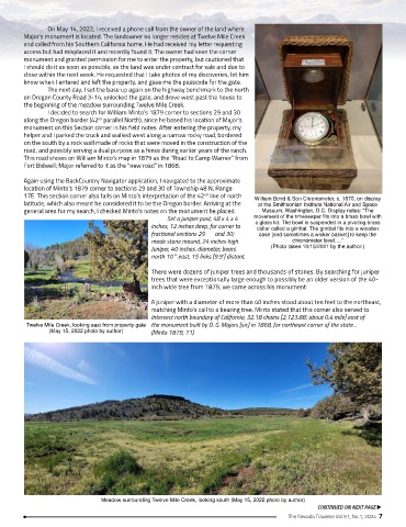
Twelve Mile Creek, looking east from property gate the monument built by D. G. Majors [sic] in 1868, for northeast corner of the state…
(May 15, 2022 photo by author) (Minto 1879, 11).
Meadow surrounding Twelve Mile Creek, looking south (May 15, 2022 photo by author)
CONTINUED ON NEXT PAGE u
The Nevada Traverse Vol.51, No.1, 2024 7