
Page 8 - 2024 - 51.1
P. 8
The Conundrum... continued from previous page
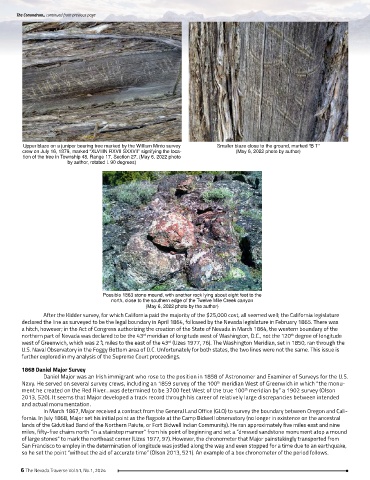
Upper blaze on a juniper bearing tree marked by the William Minto survey Smaller blaze close to the ground, marked “B T”
crew on July 16, 1879, marked “XLVIIIN RXVII SXXVII” signifying the loca- (May 6, 2022 photo by author)
tion of the tree in Township 48, Range 17, Section 27, (May 6, 2022 photo
by author, rotated L 90 degrees)
Possible 1863 stone mound, with another rock lying about eight feet to the
north, close to the southern edge of the Twelve Mile Creek canyon
(May 6, 2022 photo by the author)
After the Kidder survey, for which California paid the majority of the $25,000 cost, all seemed well; the California legislature
declared the line as surveyed to be the legal boundary in April 1864, followed by the Nevada legislature in February 1865. There was
a hitch, however; in the Act of Congress authorizing the creation of the State of Nevada in March 1864, the western boundary of the
northern part of Nevada was declared to be the 43 meridian of longitude west of Washington, D.C., not the 120 degree of longitude
rd
th
west of Greenwich, which was 2 ¾ miles to the east of the 43 (Uzes 1977, 76). The Washington Meridian, set in 1850, ran through the
rd
U.S. Naval Observatory in the Foggy Bottom area of D.C. Unfortunately for both states, the two lines were not the same. This issue is
further explored in my analysis of the Supreme Court proceedings.
1868 Daniel Major Survey
Daniel Major was an Irish immigrant who rose to the position in 1858 of Astronomer and Examiner of Surveys for the U.S.
Navy. He served on several survey crews, including an 1859 survey of the 100 meridian West of Greenwich in which “the monu-
th
ment he created on the Red River…was determined to be 3700 feet West of the true 100 meridian by” a 1902 survey (Olson
th
2013, 520). It seems that Major developed a track record through his career of relatively large discrepancies between intended
and actual monumentation.
In March 1867, Major received a contract from the General Land Office (GLO) to survey the boundary between Oregon and Cali-
fornia. In July 1868, Major set his initial point as the flagpole at the Camp Bidwell observatory (no longer in existence on the ancestral
lands of the Gidutikad Band of the Northern Paiute, or Fort Bidwell Indian Community). He ran approximately five miles east and nine
miles, fifty-five chains north “in a stairstep manner” from his point of beginning and set a ”dressed sandstone monument atop a mound
of large stones” to mark the northeast corner (Uzes 1977, 97). However, the chronometer that Major painstakingly transported from
San Francisco to employ in the determination of longitude was jostled along the way and even stopped for a time due to an earthquake,
so he set the point “without the aid of accurate time” (Olson 2013, 521). An example of a box chronometer of the period follows.
6 The Nevada Traverse Vol.51, No.1, 2024