
Page 14 - 2024 - 51.1
P. 14
The Conundrum... continued from previous page
After a century of mild to disruptive confusion over the actual boundary
between California and Nevada, the issue came to a head with questions over the
jurisdiction of casinos in development along the north shore of Lake Tahoe. With four
new casinos clustered at the border, the States decided to have the matter settled
finally. On April 22, 1977, California filed suit due to “growing doubts about the
geographic accuracy of the existing line as well as concerns regarding the validity of
certain titles which depend on the location of the border” (California v. Nevada, USSC
433 U.S. 918).
The “amicable suit” initially filed by the State of California with Nevada’s
agreement asked the United States Supreme Court to formally decree the line
marked by U.S. Deputy Surveyor Allexey von Schmidt in 1872 as the 120 meridian of
th
longitude west of Greenwich as the northeastern boundary between the two States.
The Court appointed Special Master Robert Van Pelt to investigate. In 1978,
Nevada changed its mind about its agreement with the suit, asking the Court to in-
stead honor Major’s 1868 corner monument and location of the same 120 meridian
th
as its western border; this earlier line happened to lie almost three and a half miles
west of Von Schmidt’s 1872 inter-
pretation of the same meridian. In
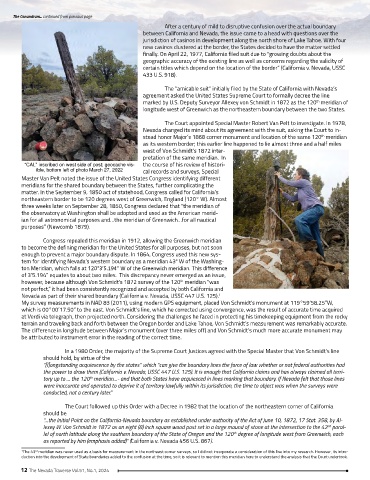
“CAL” inscribed on west side of post; geocache vis- the course of his review of histori-
ible, bottom left of photo March 27, 2022 cal records and surveys, Special
Master Van Pelt noted the issue of the United States Congress identifying different
meridians for the shared boundary between the States, further complicating the
matter. In the September 9, 1850 act of statehood, Congress called for California’s
northeastern border to be 120 degrees west of Greenwich, England (120° W). Almost
three weeks later on September 28, 1850, Congress declared that “the meridian of
the observatory at Washington shall be adopted and used as the American merid-
ian for all astronomical purposes and…the meridian of Greenwich…for all nautical
purposes” (Newcomb 1879).
Congress repealed this meridian in 1912, allowing the Greenwich meridian
to become the defining meridian for the United States for all purposes, but not soon
enough to prevent a major boundary dispute. In 1864, Congress used this new sys-
tem for identifying Nevada’s western boundary as a meridian 43° W of the Washing-
ton Meridian, which falls at 120°3’5.194” W of the Greenwich meridian. This difference
of 3’5.194” equates to about two miles. This discrepancy never emerged as an issue,
however, because although Von Schmidt’s 1872 survey of the 120 meridian “was
th
not perfect,” it had been consistently recognized and accepted by both California and
Nevada as part of their shared boundary (California v. Nevada, USSC 447 U.S. 125).
1
My survey measurements in NAD 83 (2011), using modern GPS equipment, placed Von Schmidt’s monument at 119°59’58.25”W,
which is 00°00’17.50” to the east. Von Schmidt’s line, which he corrected using convergence, was the result of accurate time acquired
at Verdi via telegraph, then projected north. Considering the challenges he faced in protecting his timekeeping equipment from the rocky
terrain and traveling back and forth between the Oregon border and Lake Tahoe, Von Schmidt’s measurement was remarkably accurate.
The difference in longitude between Major’s monument (over three miles off) and Von Schmidt’s much more accurate monument may
be attributed to instrument error in the reading of the correct time.
In a 1980 Order, the majority of the Supreme Court Justices agreed with the Special Master that Von Schmidt’s line
should hold, by virtue of the
“[l]ongstanding acquiescence by the states” which “can give the boundary lines the force of law whether or not federal authorities had
the power to draw them (California v. Nevada, USSC 447 U.S. 125). It is enough that California claims and has always claimed all terri-
tory up to … the 120 meridian…- and that both States have acquiesced in lines marking that boundary. If Nevada felt that those lines
th
were inaccurate and operated to deprive it of territory lawfully within its jurisdiction, the time to object was when the surveys were
conducted, not a century later.”
The Court followed up this Order with a Decree in 1982 that the location of the northeastern corner of California
should be
“…the Initial Point on the California-Nevada boundary as established under authority of the Act of June 10, 1872, 17 Stat. 358, by Al-
lexey W. Von Schmidt in 1872 as an eight (8) inch square wood post set in a large mound of stone at the intersection to the 42 paral-
nd
lel of north latitude along the southern boundary of the State of Oregon and the 120 degree of longitude west from Greenwich, each
th
as reported by him (emphasis added)” (California v. Nevada 456 U.S. 867).
1 The 43 meridian was never used as a basis for measurement in the northeast corner surveys, so I did not incorporate a consideration of this line into my research. However, its intro-
rd
duction into the development of State boundaries added to the confusion at the time, so it is relevant to mention this meridian here to understand the analysis that the Court undertook.
12 The Nevada Traverse Vol.51, No.1, 2024