
Page 11 - 2024 - 51.1
P. 11
1872 Allexey Von Schmidt Survey
To put an end to the confusion over the location of the 120 meridian on
th
the ground, the United States Congress authorized another border survey in 1872.
The GLO hired Allexey Von Schmidt, a Latvian immigrant who enjoyed a “prosperous
dredging business” and had participated in the survey to lay out the San Francisco
cable car system (Carle 2009). The Commissioner of the GLO asked Von Schmidt to
run the north-south part of the eastern boundary from Major’s northeast corner
monument, south to Lake Tahoe (called Lake Bigler at the time). Von Schmidt signed
the contract on July 20, 1872, received his special instructions to commence his
survey from Daniel Major’s 1868 monument on the Oregon border on July 31 , and
st
began his work on August 22 .
nd
Von Schmidt accepted the government contract job but was nonetheless
a free thinker. Along with his order for Von Schmidt to run the 120 south from
th
Major’s accepted monument, Drummond had included an instruction to determine
longitude on the Central Pacific Railroad (CPRR) by using “the most convenient sta-
tion on said Road, availing yourself of telegraphic facilities for computation of local
time with astronomic station at San Francisco or Salt Lake City…(1872 Letter, 1-2).
Von Schmidt happened to be visiting Verdi, Nevada, at the time he was to begin the
survey, and observed the U.S. Coast and Geodetic Survey (USCGS) scientist George
Davidson using the fascinating and relatively recent technology of telegraphic signals
to assist in making the astronomical calculations needed to identify the 120° line of
longitude. Von Schmidt decided to save time and money by establishing the 120
th
meridian at the Crystal Peak station near Verdi in conjunction with the USCGS station
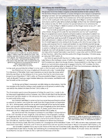
Northeast corner of California, as set by Daniel G.
Major in 1868 to mark the intersection of the 120th at San Francisco, rather than start his work at the Oregon boundary 170 miles away,
meridian west from Greenwich and the 42nd parallel as instructed (1872 Letter, 2).
north latitude. The actual coordinates of this position Von Schmidt agreed with Davidson’s finding, began to survey this line north from
are 41°59’41.64”N, 120°03’43.20”W (NAD 83), 3.24 nd
miles west of Von Schmidt’s 1872 monument that was Lake Tahoe to the northeast corner of California on August 22 , and sent word to the
upheld by the Supreme Court as the true corner in GLO Commissioner about his change of plans. He proceeded to run his flag line north
1982, and recognized today. about one hundred miles along what he gauged to be the 120 meridian, but then
th
(May 15, 2022 photo by author). received an admonishing letter on August 29 from the Commissioner ordering him
th
to stop work, proceed directly to Major’s corner, and run the line south, according to the original plan.
Von Schmidt and his crew complied with Drummond’s order, “consider[ing]
from the tenor of this letter that it was mandatory on me to take the corner estab-
lished by said Major as the initial point of my survey. And that its correctness was
known to your Department” (1872 Letter, 4). They proceeded to Major’s monument
“with all dispatch” hauling a large meridian telescope, chronometer, and field transit.
Von Schmidt set the telescope
“on the top rock of Major’s monument, and after taking my observations, I laid the
true meridian to the South by setting a small wooden pin on the ground, on which a flag
was held for line, distant 34 chains 94 links” (1872 Letter, 4-5).
The chronometer was to serve the purpose of telling the exact time, in order to de-
termine exact longitudinal position; however, Von Schmidt admitted that the delicate
instrument had been shaken on the trek across the rocky, mountainous scrub coun-
try, and could not be used.
Von Schmidt held Major’s corner as the true corner because Drummond had
so ordered; he started running the line south from the Oregon border on September
22, 1872. Unfortunately, when he met up with the latitude of the line he had earlier
been running north based on the telegraph readings of longitude at the Verdi station,
he and his crew found themselves to be 3 miles, 24 chains, and 51 links (or about
three and one-third miles) west of their abandoned line (1872 Letter, 4).
Not satisfied with the discrepancy between his and Major’s interpretations
of the 120 meridian of west longitude, and confident in his telegraphic readings
th
of longitude at Verdi, Von Schmidt returned to the 42 parallel to adjust his initial Reversed “C” scribe on bearing tree mentioned by
nd
point, despite the instructions to accept Major’s monument as the official corner. Major to establish the California side of his location of
Von Schmidt ran “east from Major’s corner the distance he determined between the 120th meridian (May 15, 2022 photo by author)
the two lines at Smoky Creek, less the correction for convergence of the meridians” (Uzes 1977, 86) and set a new northeast corner
monument three miles, 18 chains, and 73 links (or about three and one-quarter miles) east of Major’s monument (1872 Notes, p. 5).
Von Schmidt completed his survey to Lake Tahoe on this new meridional line south, reportedly hitting the nail head he had set
at Crystal Peak at Lake Tahoe, thereby “demonstrating its correctness beyond a doubt” (1872 Notes, 5). At Lake Tahoe, Von Schmidt
found that his line was 47 chains (3,102’, or almost 0.6 mile) east of the line
CONTINUED ON NEXT PAGE u
The Nevada Traverse Vol.51, No.1, 2024 9