
Page 7 - 2024 - 51.1
P. 7
The Conundrum of California’s Northeast
Corner: History, Legal Challenges,
and Retracement, Part 2
By: Laurie Pearce Price, PLS
(Note: this article served as the author’s capstone project for her 2022 Bachelor’s Degree in Land Surveying from Great Basin College.)
On May 6, 2022, I returned to this general location, this time attempting a more complete retracement of Minto’s section line
and field notes in order to find a more likely candidate for the 1863 monument. After re-shooting the corner to Sections 28, 29, 32, and
33 (Minto’s “western corner”), I walked east along the section line and did a cursory search for Minto’s temporary quarter section corner
at 40.31 chains, before proceeding east to search for the next section corner, to Sections 27, 28, 33, and 34 (Minto’s “eastern corner”).
According to his field notes, Minto had set this corner previously as he surveyed the line north between Sections 33 and 34.
Locating this corner was essential in being able to accurately track back to attempt to find the 1863 monument according
to Minto’s distance calls (at 55.5 chains east of the western section corner, which would be 25.12 chains – or 1657.92’ – west of the
eastern section corner).
The vicinity of the eastern corner was even more heavily covered in volcanic rock than the previous mile, also bordering on
Cowhead Slough, which empties into Twelve Mile Creek. In other words, there were numerous piles of rocks that looked like section
corner mounds. However, one pile was obviously human-made. Minto’s notes mentioned that he set “a volcanic stone, 20 x 13 x
10 inches” from which a “Juniper, 17 in. dia. bears north 60° east, 113 links [~75 feet] distant. Made stone mound, 24 inches high.
Land, broken and mountainous” (Minto 1879, 5). This monument’s location measured 5,388.63’, or 81.65 chains, east of the western
section corner, or about 67.71’ (1.02 chains) farther east than Minto’s calls claim; given the terrain and the available tools such as
Gunter’s chains and ropes used to measure distances in the field, this discrepancy is not unusual.
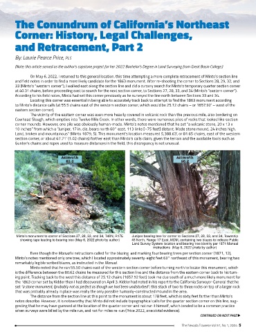
Minto’s monument to corner of Sections 27, 28, 33, and 34, T48N, R17E Juniper bearing tree for corner to Sections 27, 28, 33, and 34, Township
showing tape leading to bearing tree (May 6, 2022 photo by author) 48 North, Range 17 East, MDM, containing two blazes to indicate Public
Land Survey System location and bearing tree identity per 1871 Manual
instructions (May 6, 2022 photo by author)
Even though the Manual’s instructions called for the blazing and marking four bearing trees per section corner (1871, 12),
Minto’s notes mentioned only one tree, which I located approximately seventy-eight feet 63° northeast of this monument, bearing two
remarkably legible scribed blazes, as instructed in the Manual.
Minto noted that he ran 55.50 chains east of the western section corner before turning north to locate this monument, which
is the difference between the 80.62 chains he measured for this section line and the distance from the eastern corner back to his turn-
ing point. Tracking back to the west this distance of 25.12 chains (1657.92 feet) took me due south of a much more likely monument for
the 1863 corner set by Kidder than I had discovered on April 3. Kidder had noted in his report to the California Surveyor-General that he
set “a stone monument, (probably not as perfect as though we had been undisturbed”; this stack of two to three rocks on top of a larger rock
that was probably already in place was really the only possible humanly-constructed mound in the area.
The distance from the section line at this point to the monument is about 178 feet, which is sixty feet farther than Minto’s
notes describe. However, it is noteworthy that Minto did not include topographical calls for the quarter section corner on this line, sug-
gesting that he may have guessed at the location of the quarter corner and not run it himself, which tended to be a common practice
when surveys were billed by the mile run, and not for miles re-run (Price 2022, anecdotal evidence).
CONTINUED ON NEXT PAGE u
The Nevada Traverse Vol.51, No.1, 2024 5