
Page 15 - 2023 - 50.4
P. 15
In effect, having noticed several Paiute Indians across Twelve Mile Creek, the crew drew attention to themselves with their cries and no
doubt raised concern among the local people; the crew threw together the monument quickly and made tracks back to Lake Tahoe over
the next 17 days, as they assumed an attack was imminent (Uzes 1977, 78-80).
While I was not able to locate the maps and notes for the 1863 field survey, subsequent surveys mentioned Kidder’s monument, includ-
ing John Partridge’s 1870 and William Minto’s 1879 GLO surveys. Partridge conducted a survey of the “Eastern Boundary lines of Town-
ships 47 & 48 N. Range 16 east + 17E. (N.E. Corner of the State) Mount Diablo Meridian” in October 1870. He did locate Major’s 1868
monument, then found Kidder’s 1863 “monument of rock” and traced a path back to Major’s monument (Partridge, 1870). Minto (who
served as Partridge’s compassman in 1870), took a detour during his 1879 subdivision survey to run a line from Kidder’s monument to
Major’s monument. Minto’s survey proved crucial to my ability to locate the 1863 monument.
I attempted to locate Kidder’s monument on two different days. On April 3, 2022, after setting up the base as described in the Methods
section of this report, I parked on Modoc County California Road 1 and began my search for Kidder’s 1863 monument with an assistant.
Using GPS waypoints generated from KMZ points loaded into BackCountry Navigator, I walked around fenced private land, staying on
BLM-administered land, and navigated to William Minto’s 1879 corner monument for Sections 28, 29, 32, 33.
Minto’s notes state that he “set a volcanic stone, 37 x 8 x 4 inches, for corner to sections 28, 29, 32 and 33; made mound 24 inches
high, pits 24 x 18 x 12 inches, as per instructions” then walked “along east slope of mountain” noting that “soil, second and third rate”
with “some juniper timber” and “Sagebrush” (1879, p. 425). On the east side of a fence marking private land to the west, I found a
mound matching his description of its dimensions, albeit with a smaller standing stone (approximately 24 x 8 x 4, still well within the
504 cubic inches required in the Manual). A modern rebar with yellow plastic cap stamped PLS 4952 in the center of mound indicated
that a more recent surveyor had held Minto’s monument as the section corner in later surveys. I returned to this monument on May 6,
2022, in order to retrace Minto’s line from this location to his section corner a mile to the east, and then hopefully to walk west again in
search of his quarter corner monument and a better possibility for the 1863 monument.
Minto proceeded “East, on random line between sections 28 and 33.” After setting a temporary quarter section corner at 40 chains, he
walked 55.50 chains (3663’) east of the section corner and found the “stone mound, northeast corner of California, as established by J.F.
Kidder and Butler Ives, in 1863, north 1.80 chains [118.80’] (1879, p. 425).” As far as I know, no other survey has since located this earli-
est monument to the corner of the state.
I attempted to locate this monument on two different days in the field. On April 3, I followed these field note calls, running 55.5 chains
(3663’) east from Minto’s section corner to a point, then turning north 1.80 chains (118.8’) to begin my search for the 1863 stone
mound marking northeast corner as established by Kidder. I noted that the entire area was covered in volcanic rocks of assorted sizes;
given the prevalence of this type of terrain and the haste with which Kidder reported that his crew had built their monument, I did not
expect to see an obvious monument. The section line is currently approximated by a barbed wire fence in need of repair.
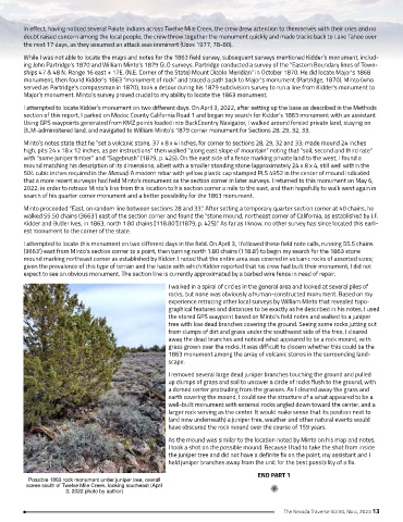
I walked in a spiral of circles in the general area and looked at several piles of
rocks, but none was obviously a human-constructed monument. Based on my
experience retracing other local surveys by William Minto that revealed topo-
graphical features and distances to be exactly as he described in his notes, I used
the stored GPS waypoint based on Minto’s field notes and walked to a juniper
tree with low dead branches covering the ground. Seeing some rocks jutting out
from clumps of dirt and grass under the southwest side of the tree, I cleared
away the dead branches and noticed what appeared to be a rock mound, with
grass grown over the rocks. It was difficult to discern whether this could be the
1863 monument among the array of volcanic stones in the surrounding land-
scape.
I removed several large dead juniper branches touching the ground and pulled
up clumps of grass and soil to uncover a circle of rocks flush to the ground, with
a domed center protruding from the grasses. As I cleared away the grass and
earth covering the mound, I could see the structure of a what appeared to be a
well-built monument with external rocks angled down toward the center, and a
larger rock serving as the center. It would make sense that its position next to
(and now underneath) a juniper tree, weather and other natural events would
have obscured the rock mound over the course of 159 years.
As the mound was similar to the location noted by Minto on his map and notes,
I took a shot on the possible mound. Because I had to take the shot from inside
the juniper tree and did not have a definite fix on the point, my assistant and I
held juniper branches away from the unit for the best possibility of a fix.
END PART 1
Possible 1863 rock monument under juniper tree, overall
scene south of Twelve Mile Creek, looking southeast (April
3, 2022 photo by author)
The Nevada Traverse Vol.50, No.4, 2023 13