
Page 12 - 2023 - 50.4
P. 12
The Conundrum... continued from previous page
STUDY AREA
The area at issue in my study encompasses approximately four miles of the boundary between Oregon and California along the 42
nd
parallel of north latitude, as it intersects the 120 meridian of longitude west of Greenwich. All of the monuments are located in or on
th
the boundary of California Fractional Township 48 North, Range 17 East of the Mount Diablo Meridian (T48N, R17E MDM). This area
includes the three monuments as set by surveyors in 1863, 1868, and 1872 to represent the northeast corner of the State of California.
Access to the study area, which follows the rugged canyon of the water body known as Twelve Mile Creek, includes county-maintained
gravel and unmaintained dirt roads northeast of Fort Bidwell, California and into southern Oregon. The county road access to the study
area, which shows as the “Road to Camp Warner” on William Minto’s detailed map below, is a graded, well-maintained gravel road; in
fact, I set up the GPS base for this study on a highway benchmark adjacent to this road after it enters Oregon. In the following image,
Minto’s map notes the location of each monument as surveyed by him in 1879. Minto’s survey is the most comprehensive record of
the three corner monuments currently available. From the west, Minto noted the monuments he found as “Major’s Initial Point” (1868
monument between Sections 30 and 31), Kidder’s 1863 “N.E. Cor of California by CA State Survey” and “Stone Mound” (between Sec-
tions 28 and 33) and Von Schmidt’s 1872 “Initial Point.”
The land surveyors who established the monuments investigated in this project characterized the land in the study area in similar ways.
John Kidder reported “the surface is rough and broken, with scattering juniper” yet with “considerable grass” in the vicinity of small
lakes and “little timber,” being “rough and
mountainous” with graveled hills that are
“smooth and rounded”; he found Twelve
Mile Creek to be “a considerable river, from
the mountains on the west, [that] flows
through a deep rocky canon” (1863, 53).
Daniel Major frequently mentioned the
“rocky worthless soil” and “mountainous
and rocky” terrain in his notes (1868, 6). Al-
lexey Von Schmidt, who set the monument
that would become the accepted corner,
described the “Land [as] rocky Tables:
rolling and broken, Sage brush and scrub
Junipers” (1872, 17).
In the course of my retracement and
location of the monuments, I found these
descriptions to be applicable. The 1863 and
1872 monuments lie on public land ad-
ministered by the Bureau of Land Manage-
ment. I accessed the 1863 monument by
Excerpt of Map of Fractional Township 47N, Range 17 E, MDM as surveyed by William Minto, Deputy walking across relatively flat land strewn
Surveyor, October 1879, showing monuments marking the corner of California set by Kidder (1863),
Major (1868), and Von Schmidt (1872). Reprinted from BLM Cadastral Survey records. with volcanic rock and juniper trees. The
1872 monument is most easily accessible
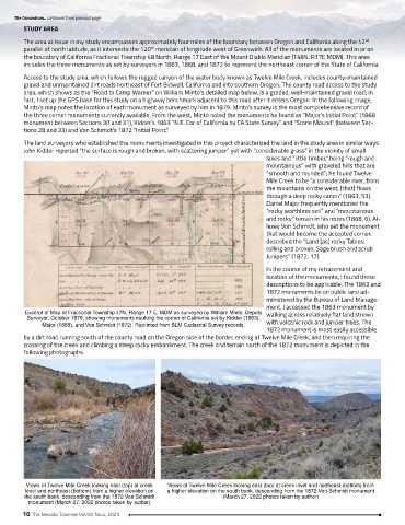
by a dirt road running south of the county road on the Oregon side of the border, ending at Twelve Mile Creek, and then requiring the
crossing of the creek and climbing a steep rocky embankment. The creek and terrain north of the 1872 monument is depicted in the
following photographs.
Views of Twelve Mile Creek looking east (top) at creek Views of Twelve Mile Creek looking east (top) at creek level and northeast (bottom) from
level and northeast (bottom) from a higher elevation on a higher elevation on the south bank, descending from the 1872 Von Schmidt monument
the south bank, descending from the 1872 Von Schmidt (March 27, 2022 photos taken by author)
monument (March 27, 2022 photos taken by author)
10 The Nevada Traverse Vol.50, No.4, 2023