
Page 13 - 2023 - 50.4
P. 13
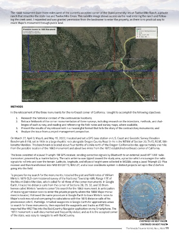
The 1868 monument (over three miles west of the currently accepted corner of the State) presently lies on Twelve Mile Ranch, a private
        ranch that straddles the state line and Twelve Mile Creek. This satellite image shows access via the road entering the ranch and follow-
        ing the creek west. I requested and was granted permission from the landowner to enter the property, as there is no practical way to
        reach Major’s monument through public land.


        METHODS

        In the retracement of the three monuments for the northeast corner of California, I sought to accomplish the following objectives:
            1.  Research the historical context of the controversial locations;
            2.  Retrace fieldwork of the corner monumentation of three surveys, including research on the intentions, methods, and chal-
                lenges of each survey, and reading and referencing the field notes and survey maps, where available;
            3.  Present the results of my retracement in a meaningful format that tells the story of the contradictory monuments; and
            4.  Analyze the issue from a project management perspective.

        On March 27, April 3, May 6, and May 15, 2022, I located and set a GPS base station on U.S. Coast and Geodetic Survey Elevation
        Benchmark A118, set in 1934 in a large rhyolitic rock alongside Oregon County Road 3-14 in the NENW of Section 20, T41S, R23E, Wil-
        lamette Meridian. This benchmark is located about four-tenths of a mile north of the Oregon-California border, approximately one mile
        from the possible location of the 1863 monument and about two miles from the 1872 established northeast corner of California.

        The base consisted of a Javad Triumph-1M GPS receiver, sending correction signals by Bluetooth to an external Javad HPT UHF radio
        transceiver, powered by a marine battery. The radio antenna was tipped toward the study area, a practice which encourages the radio
        signals to roll into and over the terrain. Latitude, longitude, and ellipsoid height were collected in WGS84 using a Javad Triumph LS-Plus
        receiver and then transformed into NAD 83 (2011), NAD 27, and a local coordinate system in distinct projects set up in the LS before
        going into the field.

        To prepare for my search for the monuments, I studied the plat and field notes of William
        Minto’s 1879 GLO-commissioned survey of the fractional Township 48N, Range 17E of
        the Mount Diablo Meridian, which called for all three of the corner monuments. In Google
        Earth, I traced his distance calls from the corner of Sections 28, 29, 32, and 33 (from
        hereon called Minto’s “western corner”) to search for the 1863 monument. In anticipation
        of receiving permission soon to enter the private property where the 1868 Major monu-
        ment is located, I followed the same procedure in Google Earth to trace Minto’s notes to
        Major’s rock mound and comparing his calculations with the 1870 distance calls of his
        predecessor John C. Partridge. I marked waypoints in Google Earth for approximate areas
        to search for these monuments, then exported the waypoints and tracks as KMZ files.                        I
        imported the KMZ files into the BackCountry Navigator application on my Smartphone. The
        1872 monument is well-documented and frequently visited, and as it is the accepted corner
        of the state, was easy to navigate to with BackCountry.
                                                                                                CONTINUED ON NEXT PAGE u
                                                                                                 CONTINUED ON NEXT PAGE u
                                                                                       The Nevada Traverse Vol.50, No.4, 2023 11