
Page 10 - 2023 - 50.4
P. 10
The Conundrum... continued from previous page
would have to cede several hundred square miles of land (and thousands of tax-
payers) along its eastern boundary, which the State was not willing to do. Nevada
achieved statehood in October 1864. The following map shows the area under ques-
tion, shaded gray.
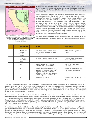
Several events arose along this area in question and precipitated the surveys that
this project investigates, starting with a conflict that erupted in Lake County (later
known as Roop County) in the Nevada Territory and Plumas County, California, both
of which claimed Honey Lake Valley (now in Lassen County, California.) Isaac Roop,
who had been the Governor of the Provisional Nevada Territory from 1859 to 1861
and joined the new Territorial Senate in 1862, supported the Nevada border extend-
ing to the Sierra Nevada mountains. The dispute culminated in the “Sagebrush War”
of 1863 in Susanville, in which the Plumas County sheriff led a 100-man posse to
lay siege to Senator Roop’s cabin, injuring one man. In an article in Nevada Surveyor,
Robert Temple (2018) depicts the skirmish as a brief tussle, ending with a round of
drinks at the town saloon and an agreement to turn the dispute over to the Gover-
nors of the Nevada Territory and California to resolve.
Map of the “disputed area” east of the Sierra Nevada
mountains claimed by both California and the Nevada This project explores original surveys and retracement surveys, including historical con-
Territory between 1861 and 1864 (WP:NFCC#4), texts, methods, and justifications for holding the three respective corner monuments:
Fair use, https://en.wikipedia.org/w/index.
php?curid=62428213
Commissioning Purpose Lead Surveyor
Body
State of Cali- Portion of Eastern Boundary from John F. Kidder, Engineer in
fornia & Lake Bigler (Tahoe) north to the 42 Charge
nd
Territory of Parallel
Nevada
US General Portion of California-Oregon boundary Daniel G. Major, U.S. Astrono-
Land Office mer and Surveyor
(GLO)
GLO Eastern boundary of T47&48N, John C. Partridge, Deputy
R16&17E (N.E. Corner of State) Surveyor
GLO Eastern boundary of the State of Allexey W. Von Schmidt, U.S.
California …that portion of the 120 Astronomer and Surveyor
th
degree of Longitude West from
Greenwich, lying between the 42nd
and 39 degree of North Latitude
th
GLO Subdivision of T48N R17E William Minto, Deputy Sur-
veyor
The Cadastral Survey Records office of the California State Office of the Bureau of Land Management (BLM) emailed PDF files of the
available maps and field notes for the surveys and retracements of the northeast corner. I was able to download field notes for surveys
from the Oregon and Nevada BLM Land Records offices. I will refer to each survey as it relates to the methods and results of my investi-
gation. Other sources include articles by James Hulse, Paul Pace, Gregory Reed, and John Wilusz, as well as Francois Uzes’s descriptions
of the procedural considerations of the surveys.
Field notes and map documents provide the record of the work that each surveyor executed on the ground as ordered by the commis-
sioning government body directing the survey. Therefore, another primary source of information was the 1855 version (and 1864 and
1871 reprints with additional clarifications) of the Manual of Surveying Instructions that served to guide all three survey parties in their
field procedures; the official title of the guide is Instructions to the Surveyors General of Public Lands of the United States for those Survey-
ing Districts Established Since the Year 1850; Containing, also, a Manual of Instructions to Regulate the Field Operations of Deputy Surveyors
(henceforth referred to as the Manual).
The existence of new States and Territories of the still-growing United States depended on the monumentation of corners; defining
geographical boundaries could be no more fundamental in the establishment of these new political spaces. The Manual did not explic-
itly mention the establishment of state boundary corners, but it did give the instructions for the marking of corner boundaries. These
instructions are relevant to the corner monuments that Kidder, Major, and Von Schmidt (and Partridge and Minto in their retracements)
set in the years following the publication of the Manual and the 1864 and 1871 updates. As my research shows, Kidder set a hasty tone
8 The Nevada Traverse Vol.50, No.4, 2023