
Page 21 - 2022- 49.3
P. 21
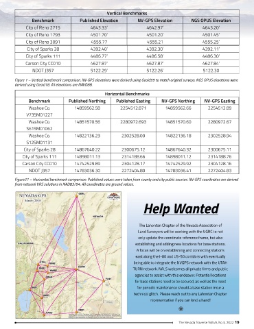
Figure 1 – Vertical benchmark comparison. NV-GPS elevations were derived using Geoid99 to match original surveys. NGS OPUS elevations were
        derived using Geoid18. All elevations are NAVD88.


        Figure21 – Horizontal benchmark comparison. Published values were taken from county and city public sources. NV-GPS coordinates are derived
        from network VRS solutions in NAD83/94. All coordinates are ground values.


                                                                      Help Wanted


                                                                    The Lahontan Chapter of the Nevada Association of
                                                                    Land Surveyors will be working with the UGRC to not
                                                                    only update the coordinate reference frame, but also
                                                                  establishing and adding new locations for base stations.
                                                                   A focus will be on establishing and connecting stations
                                                                  east along the I-80 and US-50 corridors with eventually
                                                                 being able to integrate the NVGPS network with the UTAH
                                                                 TURN network. NALS welcomes all private firms and public
                                                                  agencies to assist with this endeavor. Potential locations
                                                                  for base stations need to be secured, as well as the need
                                                                   for periodic maintenance should a base station incur a
                                                                  technical glitch. Please reach out to any Lahontan Chapter
                                                                         representative if you can lend a hand!


                                                                                       The Nevada Traverse Vol.49, No.3, 2022 19