
Page 48 - Traverse_49_1
P. 48
N A Address Service Requested Presorted
THE
Standard
PAID
The Nevada Association of Land Surveyors U.S. Postage
NALS Central Office San Dimas, CA
526 So. E Street Permit No. 410
Santa Rosa, CA 95404
R.E.Y. ENGINEERS, INC.
Civil Engineers l Land Surveyors l LiDAR
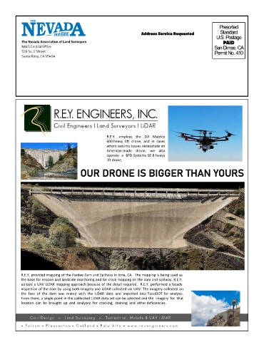
R.E.Y. employs the DJI Matrice
600 heavy lift drone, and in cases
where security issues necessitate an
American-made drone, we also
operate a BFD Systems SE-8 heavy
lift drone.
R
E
T
G
B
G
I
U
O
S
R
Y
A
H
N
S
R
O OUR DRONE IS BIGGER THAN YOURS
D
U
R
E
I
O
N
R.E.Y. provided mapping of the Pardee Dam and Spillway in Ione, CA. The mapping is being used as
the basis for erosion and landslide monitoring and for crack mapping on the dam and spillway. R.E.Y.
utilized a UAV LiDAR mapping approach because of the detail required. R.E.Y. performed a facade
inspection of the dam by using both imagery and LiDAR collected via UAV. The imagery collected on
the face of the dam was mated with the LiDAR data and imported into TopoDOT for analysis.
From there, a single point in the calibrated LiDAR data set can be selected and the imagery for that
location can be brought up and analyzed for cracking, staining and other deficiencies.
C iv il D es ig n • L a n d Su r v ey i n g • T er r es t r ia l , M o b il e & U A V L iD A R
• F ol s om • P l e a s a nt on • O a k l a nd • P a l o A l t o • w w w . r e y e ng i ne e r s . c o m