
Page 8 - Demo
P. 8
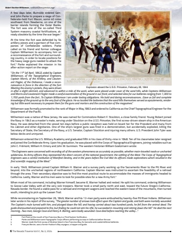
6 The Nevada Traverse Vol.51, No.3, 2024A few days later, Burnside ordered General John Parke to prepare a siege of Confederate-held Fort Macon, some 40 miles southeast from Newberne, on one of the barrier islands forming the Outer Banks. The fort was one of the so-called Third System masonry coastal fortifications, already obsolete by the time the war began.2At the time the fort was defended by 54 artillery pieces and a garrison of five companies of Confederate soldiers. Parke called on his friend and former colleague Captain Williamson to accompany him on a reconnaissance of the fort and surrounding country, in order to locate positions for the heavy siege guns needed to attack the fort.3 Parke explained the mission in his after-action report on the siege:%u201cOn the 11th (of April, 1862), aided by Captain Williamson, of the Topographical Engineers, Captain Morris, of the Artillery, and Lieutenant Flagler, of the Ordnance, I made a reconnaissance in force in the direction of the fort. Meeting the enemy%u2019s pickets, they were driven in after a slight skirmish, and advanced to within a mile of the work, when were placed under cover of the sand hills, while Captains Williamson and Morris and Lieutenant Flagler made a careful examination of the ground in our front, and selected sites for our batteries ranging from 1,300 to 1,700 yards from the fort%u2026To Captain Williamson I am under lasting obligations. His bold and daring reconnaissances%u2026Gave us full and complete knowledge of the ground up to the very foot of the glacis. He so located the batteries that the sand hills themselves served as epaulements, rendering but little work necessary to prepare them for the guns and mortars and the construction of the magazines.%u201dWilliamson was formally promoted to the rank of Major in May,1863 and ordered to California as the Chief Topographical Engineer for the Department of the Pacific.Williamson was a native of New Jersey. He was named for Commodore Robert F. Stockton, a close family friend. Young Robert joined the Navy in 1843 as a master%u2019s mate, serving under Stockton on the U.S.S. Princeton, the first screw-driven steam ship in the American Navy. He was detached from the vessel ten days before a public reception was held on board her for the President and many from his cabinet and other dignitaries. One of the ship%u2019s largest guns was fired in a demonstration, but accidentally exploded, killing the Secretary of State, the Secretary of the Navy, a U.S. Senator, Captain Stockton and injuring many others. U.S. President John Tyler was below decks and uninjured.Williamson entered the U.S. Military Academy and graduated fifth in his class of thirty-nine in 1848. Ten of his classmates later resigned and joined the Confederate Army. Upon his graduation, he was placed with the Corps of Topographical Engineers, joining notables such as John C. Fr%u00e9mont, William H. Emory and John W. Gunnison. The western historian William Goetzmann wrote:%u201cThe Engineers were concerned with recording all of the western phenomena as accurately as possible, whether main-traveled roads or uncharted wilderness. As Army officers they represented the direct concern of the national government, the settling of the West. The Corps of Topographical Engineers was a central institution of Manifest Destiny, and in the years before the Civil War its officers made explorations which resulted in the first scientific mapping of the West.%u201d In early 1949, Williamson joined Captain William H. Warner and a survey party working up the Sacramento River to the Pit River and beyond, into the uncharted regions of northeastern California. Captain Warner was instructed to ascertain the feasibility of a railroad through the area. Their secondary objective was to find the most practical route to accommodate the masses of immigrants headed to California. Lastly, Warner and his men were to look for possible sites for a new Army fort.4When most of his command, including Warner himself, became ill, Warner halted and rested. He split his command, ordering Williamson to Goose Lake Valley with all the very sick troopers. Warner took a small party north and east, toward the future Oregon-CaliforniaNevada border. He found a viable pass for a railroad and immigrant wagons and reached the eastern base of the mountains, then turned south, intending to pick up the Lassen Trail.While reconnoitering on September 26, 1849, Warner and his 12-man party were ambushed by twenty-five Pit River Indians. Williamson later wrote in his report of the survey, %u201cThe greater number of arrows took effect upon the Captain and guide, and both were mortally wounded. The Captain%u2019s mule turned with him, and plunged down the hill; and having carried about two hundred yards, he fell from the animal dead. The guide dismounted and prepared to fire, but finding he could not aim his rifle, he succeeded in mounting and retiring down the hill.5 He died the next morning%u2026Two men, George Cave and Henry A. Barling, were badly wounded. Cave died before reaching the valley%u2026%u201d.2 Fort Point at the mouth of San Francisco Bay is a Third System fortification.3 Parke and Williamson were Topographic Corps officers performing surveys in California before the war.4 Warner made the first survey of Alcatraz Island in San Francisco Bay, for barracks and coastal defense batteries.5 Fran%u00e7ois Bercier, was a former Hudson%u2019s Bay voyageur, a trapper and guide.Robert Stockton Williamson... continued from previous pageExplosion aboard the U.S.S. Princeton, February 28, 1844
